The geophysical Prospection in march 2006
-
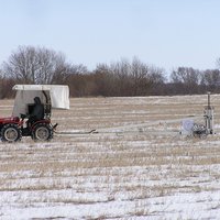
- Geomagnetical measuring in progress with tractor and equipment of the geophysicans
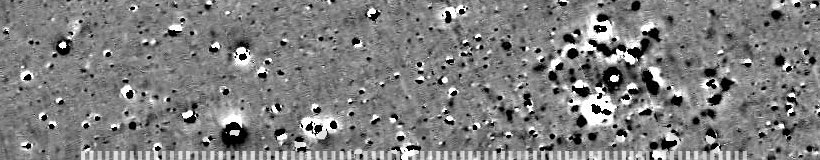
- Overview of geomagnetic measurement 2005/2006


With wide-ranged geomagnetical measurings Dr. H. Stümpel from the Institute of Geosciences of the University of Kiel and his assistants E. Erkul, T. Wunderlich and C. Podolski managed to examine an area of 45,5 ha. At three locations definite concentrations each with approx. 50-100 bigger anomalies were discovered. These areas have extensions of 150 m x 100 m. Between the single objects several linear structures can be seen, which might be interpreted as ditches or even pathes.
Due to stray finds in the direct vicinity, one concentration of anomalies seems to be connected to settlement activities of the 11th and 12th cent. A.D. This placement is underlined by C14-analysis.
Drillings in some extraordinary large objects reckon good preservation conditions for the archaeological features. In the drilling cores pieces of bones and ceramics were documented.
Clear indications for the dating the two concentrations were not yet found. Due to the drillings it is possible to point out that most of the objects are archaeologically relevant features. Some of them can be compared with the drilling results of the year 2005.
Of particular interest was the geological situation around the cemetery during the project in march 2006. The results made by the German geologists O. Jakobsen (NEZ Maasholm) and S. Pahl point out that the former coastline of the Courland Lagoon must have been situated further to the east than formerly suggested. Nevertheless, in approx. 1 km distance to the east of Wiskiauten an open water area existed for a longer period, interrupted by several land phases. In the north of the graveyard only the 30 m to 60 m wide valley of a river could be documented, which is much smaller nowadays. This river offers the possibilities for Viking Age seafaring and a harbour situation in the direct vicinity.
In the search of harbour structures or a small landing situation this information is very important and gives new evidence indicating a settlement which was connected to the Viking Age trading routes on the Baltic sea.
Excavation report in summer 2006
Between the 27th of July and the 8th of September the Archeological Museum of Schleswig (Archäologisches Landesmuseum Schleswig, Stiftung Schleswig-Holsteinische Landesmuseen Schloß Gottorf) carried out new excavations on the territory of the supposed settlement of Wiskiauten in cooperation with Prof. V. Kulakov form the Baltic expedition of the institute for Archeology of the Russian Academy of Sciences/Moscow (Балтийской археологической экспедиции Института Археологии Российской Академии Наук). The project was financed by the Roman-Germanic Commission (Römisch-Germanische Kommission Frankfurt am Main des Deutschen Archäologischen Instituts) whose director Prof. S. von Schnurbein together with Prof. C. von Carnap-Bornheim is responsible for the scientific leadership.
The recent excavations focussed on two areas.
The first excavation trench examined a feature in the south of the Viking Age barrow cemetery in the forest named "Kaup" which in 2005 was discovered by geomagentical surveys and which was partly excavated in area 2.
A second excavation called area 4 was placed 400m north of the graveyard because of some structures which reminded of ground plans of posthouses.
Beside Russian students of the Kaliningrad State University also German students of the Institut for Prehistory of the University Kiel (H. Frenzel M.A., K. Kamp, L. Schlisio und T. Schroedter) particpated in the excavations.
Preliminary results
-
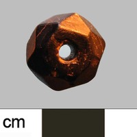
- Bead made of jet, probably an import from the black sea region, shows long distance trading relations

The two excavations of 2006 again give hints for a bigger settlement complex of local people, probably Prussians. Settlement activities in the surrounding of Wiskiauten by the new investigations can now be dated already to the late 8th cent. A.D. For the 9th and 10th cent. a trading place, partly inhabited by scandinavian merchants, can be supposed because of the finds from the graveyard itself even if there are so far no settlement traces of this time.
The settlement must have existed even after the middle of the 11th cent. A.D. when the graveyard was already given up and it probably functioned as a trading place which is expressed by the finds of scandinavian shipnails, a byzantine silver coin and the bead made of Jet (see picture)
All in all the impression of wide spread settlement activitites from the 8th to 12th cent. A.D. arises which in different times was concentrated on different spots.
The systematical investigations of the whole neighborhood of the cemetery by following excavations and ongoing geomagnetical surveys will result in interesting conclusions. For sure the village of Wiskiauten played a decisive role as a trading place in the local milieu whose importance is evidenced by the previous investigations.
[top]