Investigations in March 2009
-
- fig. 1: Complete image of the geophysical measured areas in the vicinity of Wiskiauten
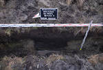
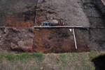
- fig. 2: One of the pits in the ditch
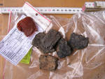
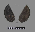
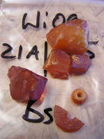
- fig. 3 Natural amber pieces and pottery


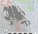
In March 2009 for 2 weeks a team of the Institute for Geosciences Kiel carried out geophysical survey under the leadership of Chr. Klein and extended the measured area to 150 ha! (fig. 1). The main aim was to fill up gaps in the already existing images to receive nearly full coverage for the suspicious settlement areas. As usual the number of anomalies was very high. Their distribution confirms the earlier supposed concentrations of anomalies resp. settlement cores.
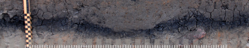
Extremely interesting was the examination of a ditch of 1km length, which was constructed for an electricity wire or a gas tube by local workers. This ditch cut into some geomagnetically surveyed areas in the north of the barrow cemetery. (see fig. 1: red line) In its profiles altogether 25 pits were documented (fig. 2).
The pits directly south of nowadays Vishnevoe (former Wosegau) approx. 800-1000 m north of the barrow cemetery near excavation area 19, conducted in 2008, contained exclusively disc made pottery whereas the pits south of excavation area 20 some 200 m west only provided hand made pottery. Moreover the pits in the west contained several bigger pieces of natural amber with a size up to 7 cm (fig. 3). All pits arise from settlement contexts. Timewise the pits south of Vishnevoe belong to the 12th cent. AD, whereas the ones in the vicinity of excavation area 20 preliminary can be dated into the second half of the first Millennium AD.
Surprisingly only 25% of all discovered pits are visible in the geomagnetical images which feeds the common suggestion that only certain features can be detected by geophysics whereas other objects are not visible. For future investigation strategies it means that one can use concentrations of anomalies to localize densely settled areas. But in addition especially the areas between the localized anomalies can contain undetectable features and should therefore also be excavated.
Results summer 2009
-
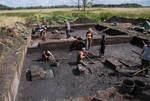
- fig. 4: Excavation area 21A

Between the 5th of July and the 30th of August summer excavations were carried out in Wiskiauten. Participants were 12 Russian Students of Immanuel-Kant-University Kaliningrad next to 8 students of the Institute for Archaeology of the CAU Kiel.
The focus lay on the region 800 m east of the Scandinavian influenced graveyard in forest “Kaup”. Prior investigation such as geomagnetics, test pits and excavations gave clear evidence for settlement traces of the 9th and 10th cent. in a distance of less than 50 m to the coastline of the former inland lake. Here a little stream flows towards the ancient shore at the foot of a little sandy peninsula, the so called “Palve”.
Already in 2007 at the banks of this stream excavations in area 5 and in test pit 16 uncovered occupation layers of 60 cm thickness. Due to the results of the Radio-Carbon-analysis some of them belong to the Bronze Age and the Pre-Roman Iron Age and furthermore to the 6th to 8th cent. AD. But moreover a part of these layers are originating from the time of the 9th to 11th cent AD when the graves in the nearby cemetery show there highest number of Scandinavian grave goods.
To check the whole situation in the east of this graveyard on the northern bank of the little river there was established excavation area “21A” with a size of 10 x 15 m (fig. 4). A north-south running profile divides the section in a western and eastern part. Excavation area “21A” in the geomagnetical images showed a small number of anomalies. It contained several occupation layers and approx. 20 clear postholes which can be connected with 2 fireplaces and indicate houses either for living or for economical purposes. A Cufic Dirhem, a small belt fitting with “eastern” ornament style and the pottery as well as the so far 3 Radio-Carbon-dates show a clear connection to Viking Age.
Excavation results:
-
- fig. 5 Oven or fireplace?
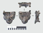
- fig. 6 Arabic silver coin
- fig. 7 Post hole
- fig. 8 Amber
- fig. 9 Belt fitting
- fig. 10 Features in excavation Area 21A, overview


In principal aforehead of the excavation a destruction of archaeological layers was expected due to agricultural ploughing in this area. For this reason the humus top soil was removed by single quadrants of 1 x 1 m and was separately water-sieved. The lack of finds in this topsoil shows that no settlement layers have been destroyed.
After removing the first 40 cm of humus the amount of finds was increasing. They lay embedded in sandy clay of grey colour. Also some bigger Stones were found in this height.
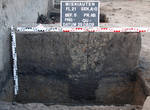
Directly in front of the northern profile in the eastern section a big concentration of burned clay with the size of 3 x 2 m was found (object 1) which already was expected after analyzing the geomagnetical images (fig. 5). Already before a segment of a Dirhem (Arabic silver coin) (fig. 6) was documented on the transition between upper humus horizon and the first occupation layer. In the same level the first post holes were recognized. They were visible as rounded features of an average diameter of 60 cm and a filling of mixed earth with a considerable high amount of charcoal and little fragments of burned clay (fig. 7). Some of them contained bigger stones to fix the posts. At the same time in the western section another fireplace was uncovered (object 2).
Beyond the grey clay layer appeared a dark brown humus layer of 20 cm thickness containing the highest number of finds. Beside many sherds of exclusively hand made pottery mainly fragmented animal bones were found. Within the numerous iron objects, mainly simple nails, most notably are some 30 rhombic plates of rivets which inter alia were used in Scandinavian ship building crafts. They might indicate that planks of wrecked ships have been used to construct houses. Several amber beads as well as their half products and raw material (fig. 8), a quite important trading good in Viking Age, give evidence for amber workshops. Iron slag and horn half products substantiate manufacturing these raw materials. A crucible allows the assumption that non-ferrous metal were processed as well. A small belt fitting with an eastern ornamentation (fig. 9) was found in the excavated earth using metal detector. For the uncovered settlement features it shows the integration into the long distance trading network of the Viking Age.
Below the big fireplace (object 1) with its large layers of vitrified clay, which preliminary is interpreted as the rests of a kiln, more post holes appeared. For the suggested building structures it leads to the assumption that there existed different phases. Especially the identical shape, filling and form of some post holes most probably show their connection to each other. They are representing a part of at least one big building with the second fireplace (object 2) in its centre (fig. 10).
Beside the pottery, which only gives an approximate dating, especially 3 radiocarbon datings can be taken into consideration. They have been analysed by the Leibniz-Laboratory for Radiometric Dating and Stable Isotope Research in Kiel. They have been analysed simultaneously to the excavations. The dates prove the contemporaneousness of the unearthed house structures and the Scandinavian influenced barrow cemetery. With results of BP 1146 +/- 25 (KIA 39644, 1-Sigma: cal AD 874-967, 2-Sigma: cal AD 782-974) for fireplace “object 2” as well as BP 972 +/- 23 (KIA 39645, 1-Sigma: cal AD 1021-1147, 2-Sigma: cal AD 1017-1154) and BP 1022 +/- 27 (KIA 39646, 1-Sigma: cal AD 994-1023, 2-Sigma: cal AD 904-1116) for fireplace “object 1” exactly in the searched time spano f the 9th to 11th cent. AD.
The results of the most recent campaign can be summarized as follows:
- The combination of different methods such as Geophysics, drillings, radiocarbon datings and small scale excavations to limit the potential Viking Age settlement areas proved successful in the 5th project year.
- For the first time within the project settlement structures could be identified which are contemporaneous to the barrow cemetery.
- These settlement structures rudimentary are comparable to other Viking Age ports of trade on the southern coast of the Baltic.
- Most probably the uncovered house structures at the banks of the former inland lake build part of the sought trading settlement.
Next summer further excavation shall uncover the complete ground plan to examine, weather the building was part of a bigger settling or just a single homestead lying in the border zone of the bigger settling or in a loose concentration of a few single homesteads missing a real centre.
[top]