Location of the site
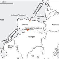
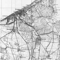
The site lies on the southern coast of the Baltic sea in the Kaliningrad Region (former northeast East Prussia) on the Sambian peninsula at the southern end of the Courland Spit, ca. 2,5 km south of Selenogradsk (former Cranz). The graveyard is situated on a mountain rigde 10 m above sealevel in a little forest of about 400 m x 500 m carrying the toponym “Kaup”.
To the north and east the terrain declines gently to a height of only 0,5 m on a length of 1 km. Here the ancient coastline of the Courland Lagoon was expected to have run in the Viking Age (cf. Kleemann 1939a, Abb. 1). The Courland Lagoon is a shallow water area with excellent conditions for Viking Age seafaring. It is distinguished from the Baltic sea by the Courland Spit and connected with the sea only by a narrow channel near Klaipeda, north of the Spit.
During the Viking Age a southern gap in the Courland Spit might have existed near Selenogradsk. Recent geological examinations corrected the ancient coastline, so that it seems as if open water must have existed only 1 km east of the graveyard for a longer period of time. It also proved that north of the graveyard, where the coastline was assumed to have been in only 1 km distance, was only a large river. A branch of the Courland Lagoon did not existed at this location.
The settlement of Wiskiauten is assumed to have been situated near the graveyard at a position where it had a direct access to the water, which is why the question of the former extension of the Lagoon is of central relevance.
The geographical position of Wiskiauten offers perfect conditions for the supra-regional Viking Age waterway trade.
Protected by the Courland Spit, ships were able to navigate on the Courland Lagoon without danger of high motion of the sea. Trading routes from the hinterland, mainly transacted over the river Memel, could be concentrated at this point and possibly controlled. Therefore, Wiskiauten takes in a strategically favourable position in the Viking Age trading network.
[top]


