The settlement
The extensive research during the German period did not give answers to the question of the settlement position. All applied test trenches as well as the wide-ranging surveys did not bring forward any results. It was not until the 1980s that Russian research registered the first small successes.
The project of 2005 used geophysical methods for the first time, providing wide-ranging insights into the ground in the periphery of the cemetery.
The geomagnetic measuring can visualise discrepancies in the natural magnetic field, which were done by humans, with special equipment and the use of computers. The pictures that are received resemble x-ray images, resulting in an archaeological map. However, they do not contain any information about the dating of the mapped objects. Regular excavations must be carried out to answer questions about the dating and the function of the discovered objects. A combination of both methods produces optimal results for archaeological research, which is why the geomagnetic method is worth its financial and organizational complexity prior to the excavation.
The archeological team carried out geomagnetical readings on an area of 18 ha in the year 2005 (see Results 2005), and in the spring of 2006 on 45,5 ha (see Results 2006). Altogether the examined area covers 63,5 ha of the potential settlement area.
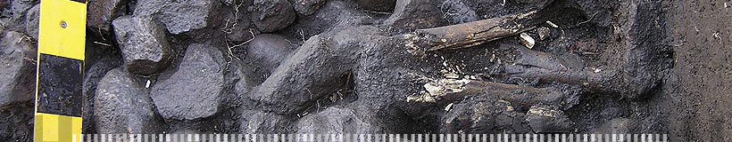
By meanwhile four excavation areas and several surveys so far five settlements can be distinguished. They disperse wide-ranging around the cemetery and belong to different times. Two zones of settlement activity originate from the 7th to 10th cent. A.D. (see Results 2005 – area 3 and Results 2007. A well built of stones can be dated to the 10th or 11th cent. A.D. (see Results 2005 – area 2, Results 2006 – area 2 and Results 2007. In another test trench there were discovered traces of nearly 60 wooden posts (see Results 2006 - area 4). They can be dated to the time of the 11th / 12th cent. A.D. whereas there are indices of earlier settlement traces of the 8th to 10th cent. A.D.
The latest evidence of occupation were recognized south of the village Wosegau/Vishnevoe. This settlement traces can clearly be seen in the geomagnetical pictures and according to finds from the surface they belong to the 12th/13th cent. A.D. (see Results 2007 - survey).
Recapitulatory in the past two project years surprisingly many traces for early medieval colonisation were found in the vicinity of the barrow cemetery of Wiskiauten/Mohovoe. So far they can be assigned to the local culture of the Prussians. Typical Scandinavian imports are still missing within the settlement finds. This result is contradictory to the huge amount of Scandinavian burial finds of the necropolis.
-
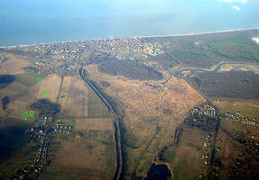
- Aerial view of the cemetery of Wiskiauten/Mohovoe with marking of the excavation areas (Foto T. Ibsen).

[top]